
Britain is bracing for a potentially record-breaking heatwave, with temperatures forecast to soar to 39C, prompting extreme heat warnings and health alerts across the country.
A rare red weather warning for extreme heat has been issued for central and southern England and Wales, in effect from 9am on Wednesday until 9pm on Thursday.
The Met Office has cautioned that this week could surpass the 35.6C June record set in Southampton in 1976, with sweltering conditions expected to persist until at least Thursday.
This unseasonably hot weather is being driven by a significant area of trapped high pressure building in Europe, known as a ‘heat dome’, which is triggering scorching temperatures across the continent.
Here we explore what causes a heat dome and how a heatwave is defined.

What is a heat dome?
A heat dome is created when a high pressure area stays over the same area for days or potentially weeks, trapping very warm air underneath it, like a lid on a saucepan. Because hot air expands, it creates a ‘dome’ that bulges out.
This weather phenomenon causes temperatures to become hotter and hotter, building through the day and rise above what is considered normal, since warm air becomes compressed over a smaller region.
The ground warms as well and moisture evaporates, the RMS says, making it easier for temperatures to continue to rise.
These weather systems and their prolonged heat also increase the risk of wildfire and heat-related health problems, the Royal Meteorological Society (RMS) said.
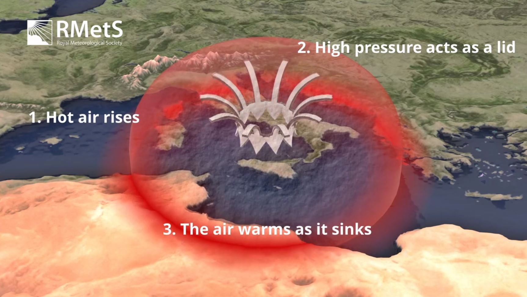
Often these pressure systems move east to west, the RMS explains. Sometimes they can be blocked when the jet stream of strong winds high in the atmosphere weakens.
Large parts of central and northwestern Europe will be covered by these conditions the coming days, with temperatures expected to reach 10C above mid-June averages, according to the Met Office.
Spain, France and Italy will see temperatures rise high into the 30Cs, and some areas will exceed 40C.
The UK will see a more varied and complex pattern, as the warm air from Europe attempts to move northwards and contrasts with low pressure in the northwest. This means northern and western parts of the UK will likely see repeated spells of rain due to the cooler weather front, while southern and eastern areas will see temperatures soar.
What is the definition of a heatwave?
A heatwave is simply a prolonged period of abnormally high temperatures. What is considered an abnormally high temperature varies from place to place.
In France, the heatwave has claimed the lives of three people due to health complications, and 2,700 schools have closed or reduced classes. Authorities across the continent issued urgent warnings for Monday as temperatures soared.
Temperatures in Bordeaux, southwestern France, were forecast to exceed a scorching 42 degrees Celsius. The national weather agency, Meteo France, confirmed 49 regional administrative areas would be under a ‘red heatwave warning’ for the day. French Health Minister Stephanie Rist told TV channel TF1: “We’re heading for, at the very least, several days of very, very hot weather. We don’t know when temperatures will start falling.”

Meanwhile, in Spain, the state weather agency Aemet issued a red alert for the Basque country. San Sebastian was projected to reach a high of 40C, almost double its historic average for this time of year, according to the Reuters Climate Monitor.
Night-time temperatures in Spain’s southwestern province of Almeria stubbornly remained above 25C, and even 30C, Aemet reported. This contributed to Europe’s average high of 24C on Monday, a significant 4.1C above its 1961-1990 historical norm, making it the continent furthest from its typical climate. Asia and North America, by comparison, were 2C and 1.3C above their historic averages.